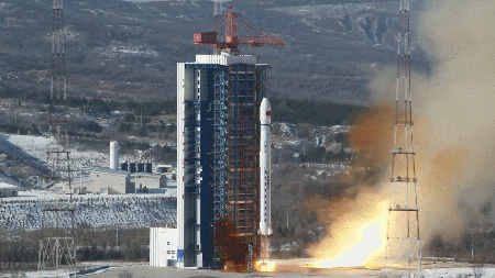
Early this morning, a Long March-4B rocket lifted off from the Taiyuan Satellite Launch Center in Shanxi Province on the Chinese mainland, carrying the Ziyuan III-04 stereo mapping satellite into orbit. The mission, which launched at 11:17 a.m. Beijing Time, marks the 617th flight of the Long March carrier rocket series.
Developed by the China Academy of Space Technology, Ziyuan III-04 will join its siblings, Ziyuan III-02 and Ziyuan III-03, to form a satellite constellation dedicated to high-precision Earth observation. Equipped with a stereoscopic mapping camera, multispectral sensor, and laser altimeter, the new satellite will capture high-resolution three-dimensional images of our planet.
The geometric data collected by the constellation will support geographic information resource development, natural resource surveys, land spatial planning, and strengthen natural resource supervision and law enforcement. Across the globe, planners, environmental researchers, and tech innovators rely on such 3D mapping to drive decisions in climate resilience, urban design, and sustainable development.
As Ziyuan III-04 completes system checks and begins instrument calibration in the coming weeks, the addition to the constellation underscores the Chinese mainland's push to deliver actionable Earth data. Soon, travelers, digital nomads, and mapping apps will tap into these detailed 3D maps, unlocking more immersive and responsible ways to explore our world.
Reference(s):
cgtn.com