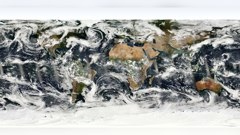
On Tuesday, the Chinese mainland's newly launched Fengyun-3H meteorological satellite released its first images, marking a milestone in global weather observation. Deployed earlier this year, Fengyun-3H is the latest in the Fengyun series and brings advanced instruments for high-definition cloud imaging, infrared sensing, and atmospheric profiling.
Measuring 5.6 meters across and weighing 2.8 tons, the satellite carries a Visible and Infrared Radiometer with 1 km spatial resolution and a Microwave Radiation Imager operating across 14 channels. These tools can capture temperature, humidity, and precipitation data with unprecedented clarity. The results? Faster storm tracking, more accurate climate models, and better early warnings for extreme events.
Analysts say Fengyun-3H's data will feed into international networks such as the World Meteorological Organization's Global Observing System, enhancing forecasts for hurricanes, monsoons, and cyclones. By fusing Fengyun-3H imagery with data from NASA, ESA and JAXA satellites, forecasters can build a near real-time view of the atmosphere, helping communities prepare for severe weather.
For young professionals in tech and startups, Fengyun-3H's open-data policy offers fresh opportunities. Developers can tap real-time imagery for AI-driven climate risk assessments, while entrepreneurs can build apps that visualize global weather patterns. The satellite also aligns with sustainability goals, providing insight into long-term climate trends and supporting disaster resilience worldwide.
As digital nomads and travelers track weather conditions across continents, Fengyun-3H's high-frequency updates promise smoother journeys. Whether you're planning a surfing trip in Indonesia, a ski tour in the Alps, or a remote work stint in Patagonia, these new images offer real-time intel on skies above.
With Fengyun-3H now online, the global community gains a powerful new tool to navigate a changing climate. Keep an eye to the skies—the satellite revolution in weather forecasting has just taken off.
Reference(s):
cgtn.com