In June, a team of researchers launched a 100-day scientific expedition along the Qiantang River in east the Chinese mainland's Zhejiang Province, aiming to decode the mystery behind the river’s famous tidal trees.
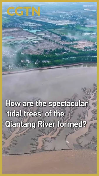
Foundations in the Flats
Data gathered from extensive tidal flats revealed that these vast, shallow areas act as a natural canvas. The tidal flats serve as the foundation as they store sediment and let currents paint patterns during each ebb and flow.
Tides as Nature’s Brush
Advanced monitoring showed how ebbing and flooding tides carve out tree-like channels in the sediment. High-resolution time-lapse images captured the dynamic interplay of water and sand, turning abstract forces into stunning natural artworks.
CT Scans and 1,600 Hidden Risks
Using robotic inspection units, the team performed a virtual CT scan of ancient sea walls lining the river. This high-tech survey uncovered over 1,600 potential hazards that could impact future coastal projects and the famous Qiantang tidal bore.
Real-World Impact
These insights are more than scientific curiosities. By mapping risk zones and understanding the mechanics behind the tidal trees, engineers can design smarter, more resilient coastal defenses—protecting communities and preserving one of nature’s most spectacular shows.
For global citizens and tech enthusiasts alike, the Qiantang’s tidal trees remind us how nature’s forces and cutting-edge science combine to shape our world—and how careful study can guide sustainable development.
Reference(s):
How are the spectacular 'tidal trees' of the Qiantang River formed?
cgtn.com