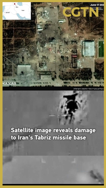
On June 17, fresh satellite imagery laid bare the aftermath of Israel's air strikes on the Iranian Revolutionary Guard Corps' (IRGC) strategic missile base in Tabriz. The high-resolution photos reveal sprawling craters, scorched launch pads, and heavily damaged command buildings within the compound.
Located in northwestern Iran, just miles from the borders with Azerbaijan and Armenia, the Tabriz base once housed short- and mid-range ballistic missiles designed to bolster Iran's regional deterrence. Analysts warn that the extensive damage could seriously weaken Iran's military posture in this key borderland.
The imagery reveals deep craters gouged into the earth and widespread scorch marks – evidence of intense fires that likely swept through launch pads and storage bunkers. Experts say the extent of destruction points to a serious blow to the base's operational capacity.
For global citizens and tech enthusiasts, these images underscore the growing role of space-based surveillance in real-time conflict analysis. Data-driven insights like these are reshaping how policymakers and strategists monitor security threats across the globe.
As discussions heat up among thought leaders and international observers, one question looms large: will Iran escalate with a counterstrike, or focus on rebuilding its missile network? Only time will tell, but the Tabriz images mark a new chapter in precision warfare and satellite-enabled accountability.
Reference(s):
Satellite image reveals damage to Iran's Tabriz missile base
cgtn.com